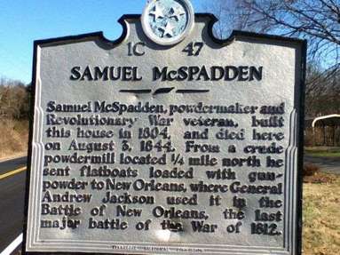
 Samuel McSpadden Revolutionary War Veteran. He enlisted from Rockbridge County VA. He served under Capt. Campbell’s Company of Col. Dickerson’s Virginia Regiment and later in Capt. McDowell’s Company of Col. Donley’s Regiment. After the war he migrated to Jefferson County, where the ancestral home still stands on the banks of the French Broad River (now Douglas Lake). He was famous for making gun powder for Gen. Andrew Jackson for the Battle of New Orleans. The home is recognized by the Tennessee Historical Commission and identified by a historical marker containing this inscription: Samuel McSpadden, powdermaker and Revolutionary War veteran, built this house in 1804, and died here on August 3, 1844. From a crude powder mill located 1/4 mile north he sent flatboats loaded with gunpowder to New Orleans, where General Andrew Jackson used it in the Battle of New Orleans, the last major battle of the War of 1812. His first wife was Sarah Keys of Virginia who died shortly after giving birth to his first child (Child later died and buried in VA.) He later remarried Nancy Harris of Tennessee. You can see a little piece of history yourself, check out where the War of 1812 Patriot spent his last years. Some locals even say they recall remembering old stories of General Andrew Jackson riding on horse back to visit Samuel. Jackson didn't become president until 1829 -1837. Classic Roadside America! If you are ever heading through Knoxville and traveling east stop off the Smoky Mountain exit to a left on Douglas Dam Rd this is the most direct route to the house, it will be on your right hand side. For a more scenic drive you will be surprised at the beauty and rolling hills on the way if you pass Douglas Dam Rd and Take a left on Old Douglas Dam Rd just a few more miles south, it still leads back to 139(Douglas Dam). You will find yourself driving past The Douglas Dam where farms and cemeteries were drowned under water from the creation of the dam in the 1940's by the Tennessee Valley Authority. TVA built the dam in record time in the early 1940s to meet emergency energy demands at the height of World War II. 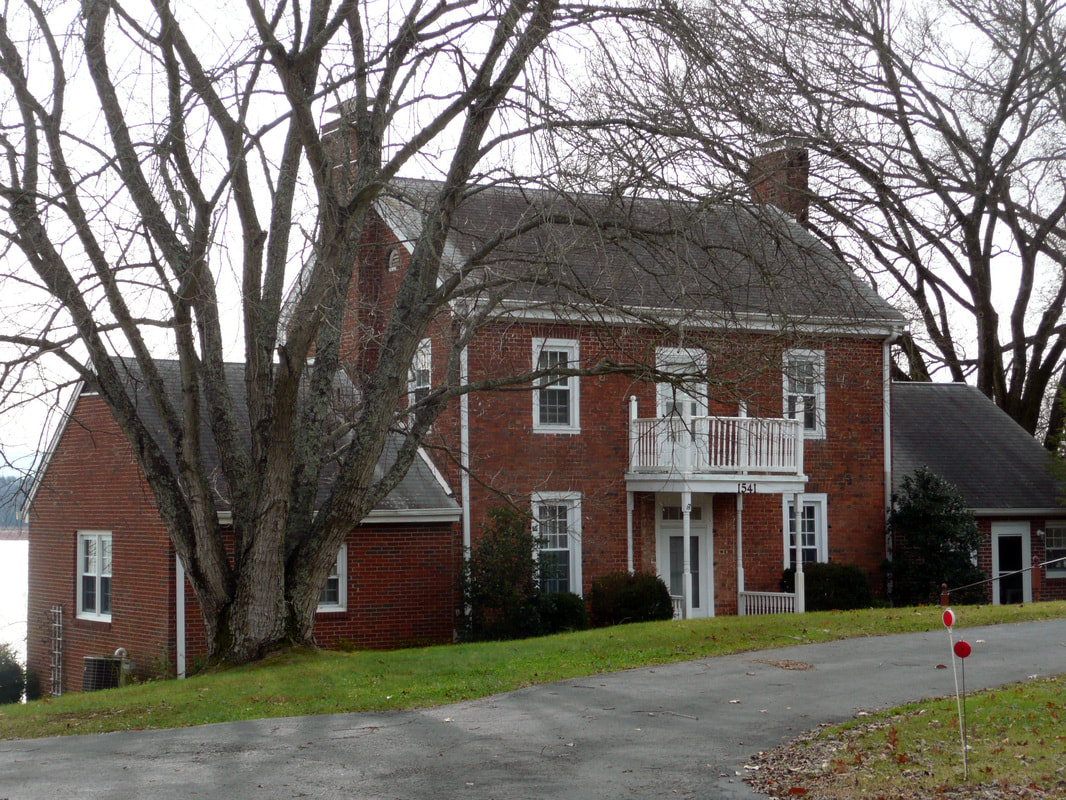 #roadsideamerica #hikedontwalk #historicarchaeology #mikethehikingguide #blogger #revolutionarywar #war1812 #generaljackson References: www.findagrave.com GPS: N 35° 58.215', W 83° 30.472'
0 Comments
Leave a Reply. |
MiketheHikingGuide
Just an explorer searching for his next adventure Archives
January 2019
Categories |
 RSS Feed
